A Map Legend Is a Set of Decisions
A map legend is a set of decisions about what readers notice. Choose symbols, labels, and omissions that make a map easier to read and interpret.
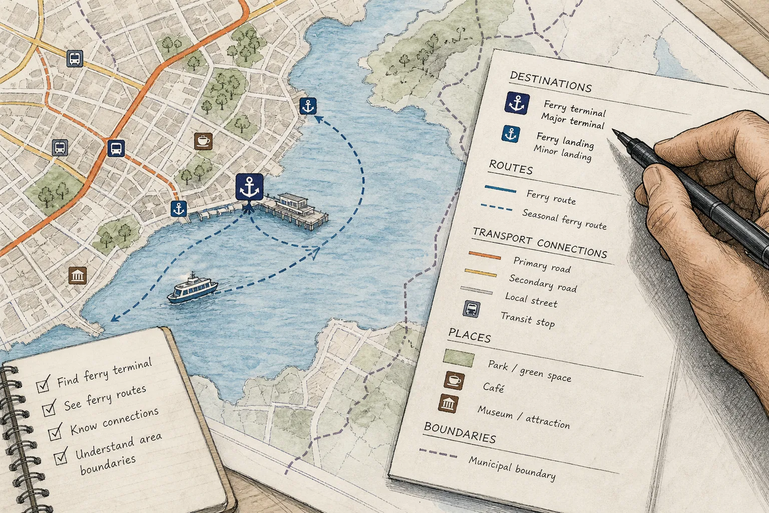
You unfold a neighborhood map to find the public ferry dock, but the legend gives three kinds of parking more space than the dock itself. A map legend is a set of decisions: it tells readers how to decode symbols, while the map’s visual choices influence what they notice first.
For a map legend, begin with the questions a reader needs answered, then check whether each symbol and label helps answer one. That approach keeps the legend tied to the map’s job instead of turning it into a catalog of every attractive icon available.
What should the map help someone do?
Describe the map’s purpose as an action: find a ferry terminal, compare public parks, or follow a route between two towns. “Show the region” is too broad to guide choices; it leaves every feature competing for room.
Name the likely reader and the setting, too. A visitor checking a printed map at a bus stop needs different cues from a planner comparing land-use layers on a desktop. Write down the specific questions the map should answer, such as where ferry docks are and which routes connect them.
Keep those questions nearby while you review the draft. If a proposed mark does not help answer one, decide whether it provides necessary context or belongs on a different map.
Which features belong in the legend?
Make an inventory of the features already shown, grouped by their role: destinations, routes, boundaries, reference points, and background geography. Then check whether each group has a distinct visual treatment and whether the legend explains the distinctions readers need.
A ferry dock might be a destination, a road leading to it a route, and a municipal boundary context for a service area. A nearby café could help on a visitor map but distract on a map focused on regional transport. The same feature can be useful in one map and irrelevant in another; cartography is not a contest to give every symbol a chair.
- Main task: If a reader cannot complete the map’s stated task without the feature, show it clearly and give it a clear legend entry. If the task remains possible without it, treat it as context or leave it out.
- Supporting context: If the feature helps explain a route, boundary, or destination, include it with quieter styling. If it adds no useful explanation, remove it.
- Duplicate categories: If two legend entries refer to the same kind of feature, combine them or explain their difference. If they represent meaningfully different things, retain separate entries and make the distinction visible.
- Unexplained symbol: If a reader cannot infer what a mark means, add a plain-language label. If its meaning is already unmistakable and carries no special distinction, omit the redundant entry.
- Unused entry: If a legend symbol does not appear on the map, remove it. If the feature should be shown, add the feature to the map and check that it serves the stated purpose.
- Clutter: If several minor marks compete with the main destinations, soften or remove the minor marks. If each is needed to understand the map, separate the information into a companion map or a clearly distinct layer.
How should symbols and labels differ?
Match the visual form to the feature. Points such as docks and towns need location marks; routes need lines; parks or administrative zones need fills or outlines. Check symbols at the size and scale at which readers will encounter the map, rather than judging them only while zoomed in on a screen.
Give features different visual weight according to their role. A primary terminal might use a dark, clear mark while a minor landing uses a lighter one. When two categories matter equally, distinguish them by shape or pattern as well as color, so their meaning does not depend on color alone.
Give labels a hierarchy of their own. Use stronger type for places readers are likely to seek, and keep supporting names quieter. If a label crosses a route junction or covers a symbol, move it with a leader line rather than shrinking all the text until it becomes fine print.
The legend should explain categories readers cannot reasonably infer. “Ferry terminal” is clearer than an unexplained anchor icon; a route line may need only a concise label. Arrange entries by their importance to the reader’s task, not by the order in which someone created them.
What might the map leave out?
Every map leaves features out because it has a purpose, a scale, and limited visual space. The relevant question is whether an omission changes how a reader might interpret or use what remains.
A ferry map that shows terminals but not the paths connecting them to nearby neighborhoods may make access appear simpler than it is. A boundary without a name or explanation can look like a natural division, even when it represents an administrative choice.
Check for absent places, groups, or routes; missing connections that could change how a destination appears; and boundaries or categories that need a source, date, or explanation. If a missing feature could affect a reader’s decision, add the context or state the map’s limits plainly. A note such as “local walking paths not shown” makes the omission legible rather than leaving it to masquerade as a complete account.
How can you check a map legend?
Read the map as someone who did not make it. Cover the legend and inspect the marks: can you tell which features are most prominent? Then cover the map and read the legend by itself: do its labels make sense without a private explanation?
Check that each symbol used on the map appears in the legend, and each legend entry appears on the map. If a blue line represents a ferry route, make sure it cannot be confused with a waterway; if both use lines, distinguish them with a clear difference in style and a direct label.
Look at the map in the form readers will use. A legend that is legible on a large monitor may be difficult to read on a printed handout. If photocopying, grayscale printing, or a small screen is likely, check that the symbols and labels remain distinct in that form.
Which map legend questions should you ask?
What belongs in a map legend?
Include the symbols and line styles needed to interpret the map’s main features. Explain boundaries or categories that are not self-explanatory, and remove entries for marks that do not appear.
How many symbols should a map use?
Use distinct symbols for the categories readers need to tell apart. If a cluster of minor categories makes the legend hard to scan, combine them only when their distinctions do not affect the map’s purpose; otherwise, separate the detail into a companion map.
Should a map legend explain every color?
Explain colors that encode a category or distinction readers need to understand. A decorative background color generally needs no entry, but a color marking protected land or a service area does.
How should a map show missing information?
Use a clear treatment, such as a dashed outline or labeled blank area, and explain what it means. If information is unavailable or outside the map’s scope, say so rather than letting an empty patch imply that the feature does not exist.
How do these choices change a map?
Say you have a draft ferry-access map for a coastal town. Its starting inventory contains three terminals, four route connections, five parking areas, six cafés, two municipal boundaries, and a road network. The stated task is to help a visitor locate a terminal and see which ferry routes connect it to other stops.
First, mark the three terminals and four route connections as central to that task, and give them the strongest symbols and lines. Next, retain the roads near the terminals as supporting context, but keep the wider road network subdued. Remove the six café symbols because they do not answer the stated questions. Keep the two municipal boundaries faint and label them because they explain a service distinction.
The expected visible result is a map where terminals and ferry connections stand out before roads and boundaries. The tradeoff is explicit: cafés no longer help with nearby amenities, so a reader seeking food would need a different map; the ferry map, meanwhile, avoids implying that its symbols cover every useful local destination.
For a map legend, the useful final check is whether the marks and their omissions let a reader understand the intended task without mistaking the map for a complete account of the place.
Keep exploring
How to Read Shared River Names on Maps
Learn how to read shared river names on maps by checking each label’s source, language, and…
The Border That Moves Without Moving
See how a border can stay fixed while rules, routes, and access change, and learn to…