How to Read Shared River Names on Maps
Learn how to read shared river names on maps by checking each label’s source, language, and reach, so local usage is not mistaken for a border claim.
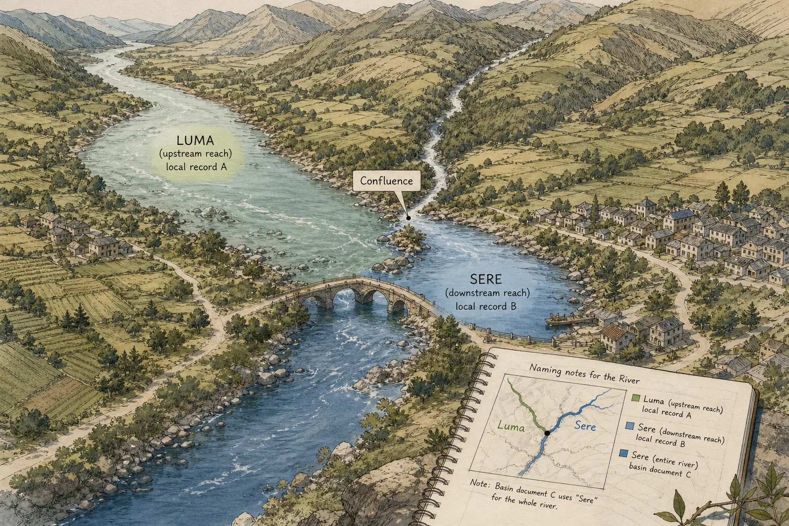
A map labels the water above a bridge “Luma” and the reach below it “Sere.” To interpret shared river names on maps, check which source uses each form, which stretch it identifies, and what naming convention the source follows.
A map can document one authority’s practice without establishing a preferred name for an entire river. The label is evidence about the map; its reach beyond the page depends on the source and its stated purpose.
Why can a shared river have several names?
People living along a river may use names in different languages, or use one name for a local reach and another farther along the channel. A map may also adopt a spelling from a particular language, writing system, or editorial standard.
These are possibilities to check, not universal rules. A government map, community record, basin document, and navigation chart may serve different purposes; none should be assumed to settle every naming question.
Record each form as it appears and identify the source that printed or published it.
What stretch does each river label identify?
A name may apply to a whole watercourse, one reach, a tributary, or the channel downstream from a confluence. Map scale and label placement can make the intended scope unclear, especially where the map has limited room.
Compare the label’s position with nearby features such as tributary junctions, settlements, bridges, and changes in the channel. Then compare maps or records made for different purposes. A basin document may label a larger system, while a local map names a shorter reach; that difference alone does not establish which name is preferred for the whole river.
If a source does not explain its naming policy or the label’s scope, note the uncertainty rather than filling it in by assumption.
How should you compare river-name sources?
For each source, record its title or issuing organization, date if supplied, language, spelling, and the stretch shown. A gazetteer or place-name index can help locate recorded forms, but read its entry as a record from that source, not automatically as a ruling for all users.
A sign can document that a form appears in a particular place. By itself, it cannot establish the preferred name for the full river. Likewise, an official map shows the standard selected by its issuing authority for its own mapping purpose; other local forms are not thereby incorrect.
Separate spelling differences from differences in scope. Two spellings may reflect transliteration from different scripts; two distinct names may refer to the same reach; or the labels may identify different reaches. A useful map note says which of these distinctions the sources support.
How do you choose a label for your map?
Start with the map’s purpose and audience. A local wayfinding map, a historical account, and a basin map may call for different choices. For navigation or public use, identify the authority or organization responsible for the map and check its applicable naming rules or guidance. Requirements vary by jurisdiction and intended use, so consult the relevant authority’s current instructions rather than assuming one naming rule applies everywhere.
If readers use more than one form, showing alternatives may be clearer than silently selecting one. If the map needs one visible label, state the selection rule—for example, following a named source for a defined reach or using the language convention specified for the mapped area.
Imagine you are making a classroom map of an invented river. Your notes list “Luma” for the upstream reach before a confluence in a local record, “Sere” for the downstream reach in another local record, and “Sere” for the full watercourse in a basin document. Mark the confluence, place “Luma” and “Sere” beside the reaches identified by the local records, and add a note that the basin document uses “Sere” for the whole river. The result distinguishes the sources’ scopes without claiming that one establishes a universally preferred name.
How should you handle spelling and translation?
Preserve the spelling used by the source you are discussing, including diacritics and spacing where your publishing system allows. If you adopt a different form for consistency, identify the standard or editorial rule behind the change rather than presenting it as a correction.
Transliteration represents a name from one writing system in another; it does not necessarily translate the name’s meaning. Different systems can produce different Latin-letter forms. Keep useful variants in an index or note when readers need to search across them, and identify their sources where possible.
If a name has a relevant literal meaning, explain it separately instead of replacing the proper name with a translation. For a formal public label, check the naming guidance of the local authority or organization responsible for the map, and follow any rules that apply to its jurisdiction and intended use.
What questions help interpret shared river names?
Does a different name mean the river changes at a border?
Not necessarily. The forms may reflect language, source policy, or different named reaches. Compare label locations and the sources’ stated scope before drawing that conclusion.
Does an official map settle the preferred name?
It establishes which form its issuing authority selected for that map’s purpose. Whether other authorities or local users prefer that form requires separate evidence.
Should a river name be translated for readers?
Usually, retain the proper name and explain a meaning separately if useful. A translated gloss might otherwise be mistaken for another established name.
What should you do with conflicting spellings?
Check the language, writing system, transliteration approach, date, and source. Choose a consistent form for your map or account, identify the rule, and preserve relevant variants.
How can you show alternate river names clearly?
Use one label per reach where the sources support that distinction, and put additional forms in a note, legend, or index. On a crowded map, a short note may be easier to read than several labels stacked over the water.
In a written account, introduce the name used by the source or community being discussed, then explain other forms and use them consistently. In a digital map, search aliases can help readers find a place under different names while the visible label follows a stated display policy.
- Observation: Two labels appear on opposite sides of a confluence. If their sources identify separate reaches, then label those reaches separately; otherwise add a note that the scope remains unclear.
- Observation: Two sources spell a name differently but locate it on the same reach. If they identify different writing or transliteration conventions, then select and cite one form for the map; otherwise retain both in a note while seeking clarification.
- Observation: A local sign displays a river name. If you need to document usage at that location, then record the sign’s place and context; otherwise do not use it alone to name the entire river.
- Observation: A basin document gives one name for a long watercourse. If your map depicts that full system and follows the document’s convention, then identify the source in the legend; otherwise show the names supported for individual reaches.
- Observation: A map omits language, date, or naming policy. If another source supplies the missing context, then compare the forms and scope; otherwise mark the uncertainty rather than inferring a standard.
- Observation: A translated phrase appears beside a proper name. If the source identifies it as a gloss, then present it as an explanation; otherwise verify whether it is a separate name before adding it as an alternate label.
For each label, identify the source, locate the reach, and state the rule behind the choice. This approach helps readers interpret shared river names on maps without asking a label to settle more than its evidence supports.
Keep naming separate from sovereignty, boundary location, and water allocation. A label alone does not resolve those matters; for a legal or diplomatic map, consult the qualified authorities and governing documents relevant to its use.
Keep exploring
The Border That Moves Without Moving
See how a border can stay fixed while rules, routes, and access change, and learn to…
A Map Legend Is a Set of Decisions
A map legend is a set of decisions about what readers notice. Choose symbols, labels, and…